Great
Ocean
Road
Apollo
Bay
to
Lavers
Hill
Side Trips
off the Great Ocean Road
Cape
Otway and Waterfalls
Travel
Notes
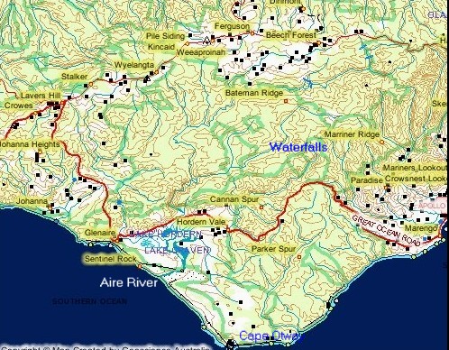
The waterfalls are to the north of this section of the
Great Ocean Road and Cape Otway is to the South.
Great
Ocean
Road
Satellite
Image
Apollo
Bay
to
Lavers
Hill
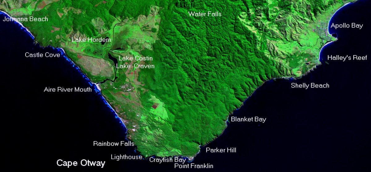
The
Great Ocean Road heads inland from Apollo Bay(right hand side of the
image)
cutting across the wider part of Cape Otway. The location of the
historic lighthouse at Cape Otway is the left hand headland at bottom
of the image. The lake and river halfway up left hand side of Cape
Otway is the Aire River. The Great Ocean Road in this section climbs
through heavy forest for most of this section then descend back to
sea level to skirt the Aire River flood plains before climbing to the
top
of the Otway Ranges at Lavers Hill. The sand dunes at the mouth of
the Aire river are clearly visible. Castle Cove(point of scenic
interest on the Great Ocean Road)is the next cove going up the left
side of the image.
Apollo Bay Lavers Hill
Road
Video
Aerial Video
Aerial
Photos Apollo
Bay
to
Cape
Otway
aerial
Picture Gallery
Maits
Rest Aire
River Castle
Cove Road
Pictures
Things
to Do and See
Apollo
Bay Cape
Otway Aire
River
Area
Lavers
Hill
Shops Fuel
Eating Accommodation Apollo
Bay
Cape
Otway Aire
River
Area Lavers
Hill
Back to Main Great Ocean Road Map
Next
Section of the Great Ocean Road Lavers Hill to Gibson's Steps
Previous Section
of the Great Ocean Road Kennett River to Apollo Bay
Great Ocean Road
Facts
Apollo Bay Lavers Hill Cape Otway
Lavers Hill is the highest point on the Great Ocean Road at 470 metres
above sea level.
Lavers Hill was named after Stephen and Rober Laver who cleared land in
1890.
First rates were charged on Lavers Hill properties in1894.
The first Lavers Hill timber mill was constructed in 1900 and the
permanent school on the existing site on the Great Ocean Road in 1910.
Lavers Hill only got electricity in 1964.
Approximately 300 people live at Lavers Hill on the Great Ocean Road.
Fuel and takeaway and sitdown food is avaible at Lavers Hill.
Mates Rest walk and picinic ground located approximately 10 kilometres
from Apollo Bay on the Great Ocean Road was an historic watering point
and rest area for timber cutters.
On this section of the Great Ocean Road access can be gained to some of
the best waterfalls in the Otway Ranges via Binns Track.
Binns track is an old forestry route back to the small township of
Beach Forest. Hopetown Falls and Beachamp Falls are accessed directly
off Binns track. Triplet Falls and Little Aire Falls are accessed from
the Beach Forest Lavers Hill road.
The worlds southern most stand of Giant Sequoias (Californian Redwoods)
is located on Binns Track where it crosses the Aire River.
Cape Otway is located approximately 12 kilometres off the Great Ocean
Road.
The Cape Otway lighthouse is the second oldest in Australia and on a
clear day the view from the top of the lighthouse is breathtaking.
Castle Cove is located on this section of the Great Ocean Road and is
close to the site of some amazing dinosaur fossil finds.
Turn off the Great Ocean Road to Red and Blue Johanna beaches for some
of the biggest surf in Victoria. When there is poor surf at Bells Beach
for the Easter World Championship the title is usually moved to Johanna.